[Flamsteed, John], The Doctrine of the Sphere, Grounded on the Motion of the Earth, And the Antient Pythagorean or Copernican System of the
World (London: A. Godbid & J. Playford, 1680) – treatise VI of: Jonas Moore, A New Systeme of the Mathematicks
(London: A. Godbid & J. Playford, 1681), 2 vols. [e-rara link].
Mayer, Tobias, “Methodus facilis et accurata computandi eclipses solares in dato loco conspicuas”, in: G.Ch. Lichtenberg (ed.),
Tobiae Mayeri, in Universitate Litt. Gottingensi quondam Professoris ac Soc. Reg. Scient. Sodalis, astronomi celeberrimi, Opera inedita,
Vol. I (Göttingen: Johann Christian Dieterich, 1775), pp. 21-30
[Google Books link] – unpublished text of a lecture
read for the Göttinger Sozietät der Wissenschaften on 3 September 1757 [see also Bode (1776) and
Forbes (1972)].
Bode, Johann Elert, “Die Mayersche Methode, Sonnenfinsternisse für einen gegebenen Ort zu berechnen, auf die Sonnenfinsterniss vom
24sten Jun. 1778 angewandt, und mit einer Construction verglichen”, Astronomisches Jahrbuch oder Ephemeriden für das Jahr 1778,
nebst einer Sammlung der neuesten in die astronomischen Wissenschaften einschlagenden Beobachtungen, Nachrichten, Bemerkungen und Abhandlungen
(Berlin: Haude und Spenerschen Buchhandlung, 1776), Zweyter Theil, 201-205
[MDZ link].
Lagrange, Joseph-Louis, “Anmerkungen über die Entwerfung der Sonnenfinsternisse und Bedeckung der Fixsterne vom Monde”, in:
Astronomisches Jahrbuch oder Ephemeriden für das Jahr 1781, nebst einer Sammlung der neuesten in die astronomischen Wissenschaften
einschlagenden Beobachtungen, Nachrichten, Bemerkungen und Abhandlungen (Berlin: Georg Jacob Decker, 1778), Zweyter Theil, 31-44
[MDZ link] – German translation by
J.K. Schulze of a lecture presented at the Berlin Academy of Sciences on 20 January 1778, the original French text was
published in Lagrange (1816).
du Séjour, Achille-Pierre Dionis, “Nouvelles méthodes analytiques pour calculer les éclipses de soleil, les occultations
des étoiles fixes et des planètes par la Lune”, Histoire et Mémoires de l’Académie Royale des Sciences [pour]
l’année M.DCCLXXVII (Paris: l’Imprimerie Royale, 1779), pp. 273-376 [Gallica
link].
Lagrange, Joseph-Louis, “Ueber die Berechnung derer Finsternisse, welche der Wirkung der Parallaxen unterworfen sind”, in:
Astronomisches Jahrbuch oder Ephemeriden für das Jahr 1782, nebst einer Sammlung der neuesten in die astronomischen Wissenschaften
einschlagenden Beobachtungen, Nachrichten, Bemerkungen und Abhandlungen (Berlin: Georg Jacob Decker, 1779), Zweyter Theil, 16-69
[MDZ link] – German translation by
J.K. Schulze, the original French text was published in Lagrange (1815).
Rüdiger, Christian Friedrich, Darstellung der neuen Methode des Herrn du Sejour Sonnen- und Mondfinsternisse für einen gegebenen
Ort Analytisch zu Berechnen: Nebst einem Entwurf der Sonnenfinsterniss am 31 Januar 1794 nach Lambert (Leipzig: Schäferischen
Buchhandlung, 1794) [GDZ link].
Delambre, Jean-Baptiste Joseph, “Formules des Hindous pour calculer les Éclipses, les Tables de sinus et divers problèmes
astronomiques”, Connaissance des Tems, ou des mouvemens célestes, à l’usage des astronomes et des navigateurs, pour
l’an 1808 (Paris: l’Imprimerie Impériale, 1806), pp. 447-453
[Gallica link].
Delambre, Jean-Baptiste Joseph, “On the Hindoo Formulæ for computing Eclipses, Tables of Sines, and various Astronomical Problems”,
The Philosophical Magazine: Comprehending the Various Branches of Science, the Liberal and Fine Arts, Agriculture, Manufactures, and Commerce,
28 (1807), 18-25 [doi link /
Google Books link] – English translation of
Delambre (1806) by T.S. Evans.
Lagrange, Joseph-Louis, “Sur le calcul des éclipses sujettes aux parallaxes”, in: Connaissance des tems, ou des mouvemens
célestes, a l’usage des astronomes et des navigateurs, pour l’an 1817 (Paris: Imprimerie de Mme Ve Courcier, 1815),
237-277 [Gallica link] – original French text of
Lagrange (1779), reprinted in: J.-A. Serret (ed.), Œuvres de Lagrange. Tome Septième (Paris: Gauthier-Villars, 1877),
pp. 413-465 [Gallica link] & 511-514
[Gallica link].
Lagrange, Joseph-Louis, “Remarques sur la Méthode des Projections pour le Calcul des Éclipses de Soleil ou d’Étoiles”,
in: Connaissance des tems, ou des mouvemens célestes, a l’usage des astronomes et des navigateurs, pour l’an 1819
(Paris: Imprimerie de Mme Ve Courcier, 1816), 344-359 [Gallica
link] – original French text of Lagrange (1778), reprinted in: J.-A. Serret (ed.), Œuvres de Lagrange. Tome Septième
(Paris: Gauthier-Villars, 1877), pp. 391-412 [Gallica link].
Ursin, Georg Frederik Krüger, De eclipsi solari die VII Septembris 1820 apparitura: secundum methodum geometriæ analyticæ tractata
dissertatio (Copenhagen: ???, 1820).
Ursin, Georg Frederik Krüger, Om den ringformige Soelformørkelse 7de September 1820 især for Danmark (Copenhagen: Det Schultziske
Officin, [1820]) [DKB link].
Bessel, Friedrich Wilhelm, “Berechnung verschiedener Sternbedeckungen von den Herren Rosenberger, Strehlke und Klupsz”, Astronomische
Nachrichten, 3 (1824), 17-28 [ADS link] &
33-46 [ADS link].
Bessel, Friedrich Wilhelm, “Ueber die Vorausberechnung der Sternbedeckungen”, Astronomische Nachrichten, 7 (1828),
1-14 [ADS link] – reprinted in Encke (1829),
pp. 257-274, and in Bessel (1842), Abhandlung X.3.
Bessel, Friedrich Wilhelm, “On the Calculations Requisite for Predicting Occultations of Stars by the Moon”, The
Philosophical Magazine, or Annals of Chemistry, Mathematics, Astronomy, Natural History, and General Science, 6 (1829), 336-342 &
410-416 [doi link / doi link] – English translation of Bessel (1828).
Bessel, Friedrich Wilhelm, “Beiträge zur Theorie der Finsternisse und den Berechnungs-Methoden derselben”, Astronomische
Nachrichten, 7 (1829), 121-136 [ADS link]
& 137-144 [ADS link] – reprinted in Bessel
(1842), Abhandlung X.4.
Encke, Johann Franz, Berliner Astronomisches Jahrbuch für 1831 (Berlin: Druckerei der Königl. Akademie der Wissenschaften,
1829) [MDZ link].
Bessel, Friedrich Wilhelm, “Additions to the Theory of Eclipses, and the Methods of Calculating their Results”,
The Philosophical Magazine, or Annals of Chemistry, Mathematics, Astronomy, Natural History, and General Science,
8 (1830), 268-275, 342-347 & 417-423 [doi link /
doi link / doi link] – English translation of Bessel (1829).
Woolhouse, Wesley Stoker Barker, “On Eclipses”, in: The Nautical Almanac and Astronomical Ephemeris for the Year 1836. With an
Appendix (London: John Murray, 1834), Appendix, 53-148 [Google
Books link].
Lubbock, John William, An Elementary Treatise on the Computation of Eclipses and Occultations (London: Charles Knight, 1835)
[Google Books link] – summary in Monthly Notices of
the Royal Astronomical Society, 3 (1835), 107-108 [ADS link].
Bessel, Friedrich Wilhelm, “Ueber die Grundgleichung der Theorie der Finsternisse”, Astronomische Nachrichten, 14 (1836),
129-138 [ADS link] – reprinted in Bessel (1842),
Abhandlung X.1.
Hansen, Peter Andreas, “Ueber die Verfinsterungen auf der Erde überhaupt”, Astronomische Nachrichten, 15
(1837) 33-104 [ADS link].
Rümker, Carl Ludwig Christian, Ueber die Berechnung der Sonnenfinsternisse, oder einfache Berechnungs-Methode der Finsternisse für die
Oberfläche der Erde im Allgemeinen, wie auch specieller Fälle als Berechnung der wahren Conjunction aus dem beobachteten Anfange und Ende
oder Vorherbestimmung des Anfanges und Endes für einen bestimmten Ort, mit Anwendung auf die Sonnenfinsterniss am 3.-4. März 1840 und einer
Entwerfung dieser Finsterniss nach ortographischer Projection (Hamburg: Langhoffschen Buchdruckerei, 1837)
[e-rara link].
Hansen, Peter Andreas, “Ueber den Einfluss der Strahlenbrechung auf Sonnenfinsternisse und Sternbedeckungen. Ein Nachtrag zu der in
Nr. 339-342 abgedruckten Abhandlung”, Astronomische Nachrichten, 15 (1838) 185-192
[ADS link].
Bessel, Friedrich Wilhelm, “Analyse der Finsternisse”, in: Astronomische Untersuchungen (Königsberg: Verlag der
Gebrüder Bornträger, 1841-1842), Abhandlung X [Band II, pp. 95-240]
[e-rara link] – reprinted in Bessel (1876), Band III,
369-428 [Abhandlung 169].
Leonhardi, Gottfried Wilhelm, Anleitung zur Berechnung und graphischen Bestimmung der Sonnenfinsternisse und Mondfinsternisse für
angehende Astronomen und Mathematiker: Mit zwei Figurentafeln und Tabellen zur angenäherten Berechnung der Zeit der in die drei Jahrhunderte
1700 bis 2000 fallenden Vollmonde, Neumonde und Finsternisse (Leipzig: Friedrich Fleischer, 1846)
[SLUB link].
Shadwell, Charles Frederick Alexander, Tables for Facilitating the Approximate Prediction of Occultations and Eclipses for any Particular
Place (London: R.B. Bate, 1847) [HathiTrust Library link].
Peirce, Benjamin, The Chapter on Eclipses, Extracted from Peirce’s Spherical Astronomy, for the Use of the Nautical Almanac
(Boston/Cambridge [MA]: James Munroe and Company, 1852) [HathiTrust
Library link].
Hansen, Peter Andreas, “Ecliptische Tafeln für die Conjunctionen des Mondes und der Sonne, nebst Angabe einer wesentlichen
Abkürzung der Berechnung einer Sonnenfinsterniss”, Berichte über die Verhandlungen der Königlich Sächsischen
Gesellschaft der Wissenschaften zu Leipzig, Mathematisch-Physische Classe, 9 (1857), 75-112
[MDZ link].
Drechsler, Adolph, Die Sonnen- und Mondfinsternisse in ihrem Verlaufe, oder Anleitung wie diese durch Rechnung oder Zeichnung zu ermitteln
sind (Dresden: Rudolf Kuntze, 1858) [Google Books link].
Hansen, Peter Andreas, “Theorie der Sonnenfinsternisse und verwandten Erscheinungen”, Abhandlungen der Mathematisch-Physischen
Klasse der Königlich-Sächsischen Gesellschaft der Wissenschaften, 6 (1859), 303-454
[SLUB Dresden link] – also published as a separatum
[HathiTrust Library link].
Hansen, Peter Andreas, “Analyse der ecliptischen Tafeln”, Berichte über die Verhandlungen der Königlich Sächsischen
Gesellschaft der Wissenschaften zu Leipzig, Mathematisch-Physische Classe, 15 (1863), 143-174
[MDZ link].
Chauvenet, William, A Manual of Spherical and Practical Astronomy, Embracing the General Problems of Spherical Astronomy, the Special
Applications to Nautical Astronomy, and the Theory and Use of Fixed and Portable Astronomical Instruments, with an Appendix on the Method of
Least Squares (Philadelphia: J.B. Lippincott & Co., 1863), 2 vols. [HathiTrust Library link] – 2nd rev. ed. 1864 / 3rd rev. ed. 186? / 4th rev. ed. 1868
(reprinted 1871 & 1873) / 5th rev. ed. 1874 (reprinted 1876, 1885, 1887, 1889, 1891, 1893, 1896, 1900, 1903, 1908 & 1960 [Dover Publications
(New York)]) – Volume 1, Chapter X, discusses solar and lunar eclipses and transits.
Cayley, Arthur, “On the Graphical Construction of the Umbral or Penumbral Curve at any Instant during a Solar Eclipse”, Monthly
Notices of the Royal Astronomical Society, 30 (1870), 162-164 [ADS link] – note that the page number 164 is misprinted as 166.
Cayley, Arthur, “On the Geometrical Theory of Solar Eclipses”, Monthly Notices of the Royal Astronomical Society, 30
(1870), 164-168 [ADS link] – note that the page number
164 is misprinted as 166.
Garbich, N., Analytische Methode zur Berechnung der Sonnenfinsternisse sowie aller anderen Occultationen (Triest: F.H. Schimpff,
1871) [HathiTrust Library link].
Cayley, Arthur, “On the Graphical Construction of a Solar Eclipse”, Memoirs of the Royal Astronomical Society, 39 (1872),
1-17 [Internet Archive link].
Fleck, J.M., “Calcul des éclipses de soleil par la méthode des projections”, Mémoires de l’Académie de
Metz, 55 [= Troisième Série, 3] (1875), 381-386 [Google Books link].
Engelmann, Rudolph (ed.), Abhandlungen von Friedrich Wilhelm Bessel (Leipzig: Verlag von Wilhelm Engelmann, 1875-1876), 3 vols.
[e-rara link].
von Oppolzer, Theodor, Syzygien-Tafeln für den Mond: Nebst ausführlicher Anweisung zum Gebrauche derselben (Leipzig: Wilhelm
Engelmann, 1881 [= Publicationen der astronomischen Gesellschaft, Band XVI]) [Google Books link].
Lehmann, Paul, Tafeln zur Berechnung der Mondphasen und der Sonnen- und Mondfinsternisse (Vienna: Verlag des Königlichen Statistischen
Bureaus, 1882 [= Serie V der Kalendermateri???]) [digi-hub link].
von Oppolzer, Theodor, “Tafeln zur Berechnung der Mondesfinsternisse”, Denkschriften der Kaiserlichen Akademie der Wissenschaften,
Mathematisch-Naturwissenschaftlichen Classe, 47 (1883), 243-275 [ZOBODAT link].
Ginzel, Friedrich Karl, “Ueber eine neue Bestimmung empirischer Correctionen der Mondbahn behufs Darstelliung der Finsternisse”,
Astronomische Nachrichten, 109 (1884), 173-186 [ADS
link].
Paulus, Ch., Tafeln zur Berechnung der Mondphasen. Zum Gebrauch beim Unterricht in der mathematischen Geographie, entworfen und mit erklärendem
Texte herausgegeben (Tübingen: Verlag und Druck von Franz Fues, 1885) [Google Books link].
Keutzer, Hans, Berechnung von Finsternissen (Offenbach am Main: Kohler & Teller, 1886 [= Programm des Grossherzoglichen Realgymnasiums
und der Realschule zu Offenbach am Main]) [HHU
link].
Schram, Robert, “Tafeln zur Berechnung der näheren Umstände der Sonnefinsternisse”, Denkschriften der Kaiserlichen Akademie
der Wissenschaften, Mathematisch-Naturwissenschaftlichen Classe, 51 (1886), 385-576 [??? link] –
also published as a separatum [Google Books link].
Schram, Robert, “Reductionstafeln für den Oppolzer’schen Finsterniss-Canon zum Übergang auf die Ginzel’schen empirischen
Correctionen”, Denkschriften der Kaiserlichen Akademie der Wissenschaften, Mathematisch-Naturwissenschaftliche Classe,
56
(1889), 187-256 [Google Books link] – also published as a
separatum [Google Books link].
Beau, Otto, Die Berechnung der Sonnen- und Mondfinsternisse: Für den Selbstunterricht entwickelt und mit Rechnungsergebnissen versehen
(Halle a. S.: ???, 1897-1903):
I. Teil. Theoretische Erörterungen und Beispiele (Halle a. S.: ???, 1897 [=
Osterprogram des Gymnasiums zu Sorau, nr. 86]) [??? link]..
II. Teil. Tafeln und Rechnungsergebnisse (Sorau: Emil Zeidler, 1897) [not seen].
III. Teil. Die ausführliche Berechnung der Sonnenfinsternisse (Halle a. S.:
???, 1901 [=
Osterprogram des Gymnasiums zu Sorau, nr. ??) [??? link].
IV. Teil. Die ringförmige-totale Sonnenfinsternis am 17. April 1912. als Rechnungsbeispiel dargestellt (Halle a. S.:
???, 1903 [= Osterprogram des Gymnasiums zu Sorau, nr. ??])
[??? link].
Ginzel, Friedrich Karl, “Bemerkungen über den Werth der alten historischen Sonnenfinsternisse für die Mondtheorie”, Astronomische
Nachrichten, 150 (1899), 1-8 [ADS link].
Auhagen, Wilhelm, “Note on Chauvenet’s Theory of Solar Eclipses”, The Astronomical Journal, 22 (1902), 105
[ADS link].
Buchanan, Roberdeau, The Mathematical Theory of Eclipses According to Chauvenet’s Transformation of Bessel’s Method, Explained and
Illustrated, to Which are Appended Transits of Mercury and Venus and Occultations of Fixed Stars (Philadelphia/London: J.B. Lippincott
Company, 1904) [Internet Archive link].
Beau, Otto, Die Berechnung der Sonnen- und Mondfinsternisse, nebst Berechnung der Mondphasen: Ein Lehrbuch auf elementarer Grundlage für
den Selbstunterricht bearbeitet und mit Rechnungsergebnissen versehen (Halle a. S.: L. Nebert, 1908) [not
seen].
Schwahn, Paul, Mathematische Theorie der astronomischen Finsternisse (Leipzig/Berlin: B.G. Teubner, 1910 [= Mathematisch-Physikalische
Schriften für Ingenieure und Studierende, Band 8]) [Internet Archive link].
Prey, Adalbert Johann, “Bemerkungen zu Hansens »Theorie der Sonnenfinsternisse«”, Astronomische Nachrichten,
196 (1913), 97-102 [ADS link].
Demetrescu, Gheorghe, “Sur une méthode de calcul des éclipses de Soleil”, Bulletin astronomique,
Série I, 31 (1914), 305-328 [ADS link /
Persée link /
doi link].
Andoyer, Marie Henri, “Sur la prédiction des éclipses”, Bulletin astronomique, Série I, 33
(1916), 5-51 [ADS link /
Persée link /
doi link].
Lewis, Isabel Martin, A Handbook of Solar Eclipses (New York: Duffield & Company, 1924)
[HathiTrust Library link].
Schoch, Carl, “Verbesserung der Schramschen Sonnenfinsternis-Tafeln”, Sirius: Rundschau der gesamten Sternforschung für
Freunde der Himmelskunde und Fachastronomen, 59 [= NF, 54] (1926), 274-278 [pdf link].
Comrie, Leslie, John, “Some Computational Problems Arising in Eclipses”, Monthly Notices of the Royal Astronomical Society,
87 (1927), 483-496 [ADS link].
Michailov, Aleksandr Aleksandrowitch, “Über die Berechnung der Breite der Totalitätszone bei Sonnenfinsternissen”,
Astronomische Nachrichten, 243 (1931), 49-54 [ADS link].
Comrie, Leslie, John, “The Computation of Total Solar Eclipses”, Monthly Notices of the Royal Astronomical Society,
93 (1933), 175-181 [ADS link].
Dyson, Frank & Woolley, Richard van der Riet, Eclipses of the Sun and Moon (Oxford: Clarendon Press, 1937)
[Internet Archive link].
H.M. Nautical Almanac Office, “The Ionospheric Eclipse of 1940 October 1”, Monthly Notices of the Royal Astronomical
Society, 98 (1938), 664-669 [ADS link].
H.M. Nautical Almanac Office, “The Corpuscular Eclipse of 1940 October 1”, Monthly Notices of the Royal Astronomical
Society, 98 (1938), 727-733 [ADS link].
Lewis, Isabel Martin, “Formulas for the Ionosphere Track in Eclipses”, The Astronomical Journal, 49 (1940), 4-7
[ADS link].
Danjon, André, “Les éclipses de Lune par la pénombre en 1951”, l’Astronomie: Bulletin de la Société
Astronomique de France et revue mensuelle d’astronomie, de météorologie et de physique du globe, 65 (1951) 51-53
[ADS link].
Danjon, André, Astronomie générale: Astronomie sphérique et éléments de mécanique céleste (Paris:
J. et R. Sennac, 1952) – eclipses of the Moon and the Sun are covered in chapter XIV; reprinted with additions and corrections in
1959 & 1980.
Mikhailov, Aleksandr Aleksandrowitch, Teoriya Zatmennii (???: ???, 1954)
[pdf link].
Meeus, Jean, “Calcul de la grandeur maximum d’une éclipse partielle de Soleil”, Ciel et Terre: Bulletin de la
Société Belge d’Astronomie, de Météorologie et de Physique du Globe, 71 (1955), 415-425
[ADS link].
Gossner, Simone Daro, “A Correction to the Time of Maximum Obscuration in Solar Eclpses”, The Astronomical Journal,
60 (1955), 383-384 [ADS link].
Meeus, Jean, “A propos des corrections différentielles aux instants des phases des éclipses de Soleil”,
Ciel et Terre: Bulletin de la Société Belge d’Astronomie, de Météorologie et de Physique du Globe,
75 (1959), 251-255 [ADS link].
Meeus, Jean, “L’éclipse totale de Soleil du 15 février 1961”, Ciel et Terre: Bulletin de la
Société Belge d’Astronomie, de Météorologie et de Physique du Globe, 76 (1960), 166-172
[ADS link].
Explanatory Supplement to the Astronomical Ephemeris and the American Ephemeris and Nautical Almanac (London: Her Majesty’s Stationery
Office, 1961) [Internet Archive link] – eclipses of the Sun
and the Moon are covered in chapter 9.
Meeus, Jean, Tables of Moon and Sun (Kessel-Lo: Kesselberg Sterrenwacht, 1962) – computational precedures for predicting eclipses of the
Sun and the Moon are treated in chapter IV.
Debehogne, Henri, “Nouvelle méthode de détermination des corrections différentielles pour les éclipses de Soleil par
application de la méthode des moindres carrés. Calcul des phases et éléments locaux des éclipses par ordinateur
électronique”, Bulletins de l’Académie Royale de Belgique, 54 (1968), 1192-1198
[doi link].
Link, Frantisek, Eclipse Phenomena in Astronomy (Berlin/Heidelberg/New York: Springer-Verlag, 1969).
Meeus, Jean, “Die Abplattung des Erdschattens bei Mondfinsternissen”, Die Sterne: Zeitschrift für alle Gebiete der
Himmelskunde, 45 (1969), 116-117 [ADS link
/ pdf link] – with an additional note by Paul Ahnert.
Wentworth, Williams Jr., Prediction and Analysis of Solar Eclipse Circumstances (Bedford [MA]: Air Force Cambridge Research Laboratories,
1971 [= AFRCL-71-0049]) [DTIC link].
Forbes, Eric G., “Tobias Mayer’s Method for Calculating the Circumstances of a Solar Eclipse”, Annals of Science, 28
(1972), 177-189 [doi link].
Mogenet, Joseph; Tihon, Anne & Donnet, Daniel, Barlaam de Seminara: Traités sur les éclipses de soleil de 1333 et 1337 –
Histoire de textes, éditions critiques, traductions et commentaires (Louvain: Éditions Peeters, 1977).
Mogenet, Joseph; Tihon, Anne; Royez, Robert & Berg, Anne, Nicéphore Grégoras: Calcul de l’éclipse de soleil du
16 juillet 1330 (Amsterdam: J.C. Gieben, 1983 [= Corpus des astronomes byzantins, vol. I]).
Green, Robin M., Spherical Astronomy (Cambridge: Cambridge University Press, 1985) – chapter 18 of this book contains an
up-to-date vector/matrix treatment of the basic eclipse calculations based on Bessel’s formulation.
Soulsby, Byron W., “Improved Lunar Eclipse Ephemerides”, Journal of the British Astronomical Association, 100 (1990),
293-305 [ADS link].
Seidelmann, P. Kenneth (ed.), Explanatory Supplement to the Astronomical Almanac: A Revision to the Explanatory Supplement to the Astronomical
Ephemeris and the American Ephemeris and the Nautical Almanac (Mill Valley [CA]: University Science Books, 1992)
[Internet Archive link] –
eclipses of the Sun and the Moon are covered in chapter 8.
Carton, Wilhelm H.C., “The Speed of the Lunar Shadow on Earth During Solar Eclipses”, Journal of the British Astronomical
Association, 121 (2011), 105-108 [ADS
link].
Montelle, Clemency, Chasing Shadows: Mathematics, Astronomy, and the Early History of Eclipse Reckoning (Baltimore: Johns Hopkins University
Press, 2011).
Urban, Sean E. & Seidelmann, P. Kenneth (eds.), Explanatory Supplement to the Astronomical Almanac: Third Edition (Mill Valley [CA]:
University Science Books, 2013) – eclipses of the Sun and Moon are covered in chapter 11.
Berthier, Jérôme; Descamps, Pascal & Mignard, François (eds.), Introduction aux éphémérides et
phénomènes astronomiques: Supplément explicatif à la Connaissance des temps (Paris: Institut de Mécanique Céleste
et de Calcul des Éphémérides / Bureau des Longitudes, 2021) – eclipses of the Sun and the Moon are covered in chapter 11.
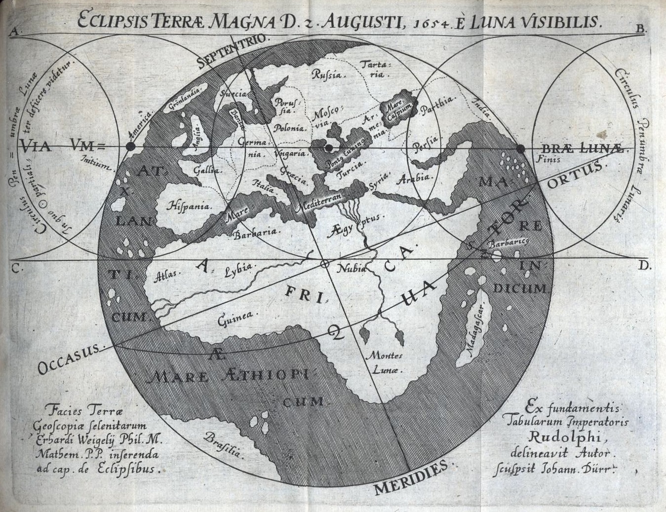
The earliest solar eclipse map, as computed from the Rudolphine Tables for the solar eclipse of 12 August 1654 by
Erhard Weigel of Jena. Note that the date mentioned on
the map is given in the Julian calendar.
An eclipse map is a geographical map depicting the region from which a specific solar eclipse can be seen. Commonly shown are the central line, the northern
and southern limits, lines of equal maximum obscuration and curves delineating where the eclipse begins at sunrise and ends at sunset.
Weigel, Erhard, De Eclipsibus, tùm in genere, tum in specie, De Magna Solis Eclipsi, d 2. Aug. proximè futurâ (Jena:
Georg Sengenwald, 1654) [ThuLB Jena link].
Cassini, Giovanni Domenico, Osservazione dell’ ecclisse solare fatta in Ferrara l’anno 1664, con una figura intagliata in rame che
rappresenta un nouovo methodo di trovar l’apparenze varie che fa nel medessimo tempo in tuta la terra (Ferrara:
???, 1664) [??? link].
Sturm, Johann Christoph, Alter und Neuer Recht-Astronomischer, von allen Aberglaubischen Waarsagereyen und Ungewißheiten gesäuberter
und Absonderlich so genannter Finsternissen-Calender. Als in welchem Nicht allein ins gemein, was die Finsternissen seyen, woher sie kommen, und was
von ihren Bedeutungen und Würkungen zu halten, &c. gehandelt wird, Sondern auch Auf jedes, also dißmal auf dieses M.DC.LXXVI. Jahr nach
Christi Geburt, als das 419. SchaltJahr. Die erwartende Sonnen- und Mond-Finsternissen auf eine besondere Weise beschrieben werden, Auch Neben
ordentlicher Ansetzung jeder Fest und Feyertäge und was sonsten dahin gehöret, Die Stund und Minute, wann der Mond aus einem Zeichen in
das andere gehet..., Durch alle zwölff Monaten des ganzen Jahrs dem gemeinen Mann so wol, als curieusen Gemüthern, zu Nutzen und Gefallen
angezeigt wird (Nuremberg: Christoph Gerhard, 1675) – facsimile reprint: Klaus-Dieter Herbst (ed.), Finsternissen-Calender
für das Jahr 1676 verfaßt von Johann Christoph Sturm (Jena: Verlag HKD, 2013 [= Acta Calendariographica, Kalenderreihen,
Band 2.2]).
Sommerville, Duncan MacLaren Young, “On the Form of an Eclipse Chart near the Pole”, Monthly Notices of the Royal Astronomical Society,
79 (1919), 613-618 [ADS link].
Rigge, William F., “When an Eclipse Prevented a War”, Popular Astronomy: A Review of Astronomy and Allied Sciences,
28 (1920) 321-325 [ADS link].
Snow, Arthur, “The Node of Solar Eclipses, and Related Phenomena”, Popular Astronomy: A Review of Astronomy and Allied Sciences,
30 (1922) 28-31 [ADS link].
Rigge, William F., “The Accuracy of Oppolzer’s Eclipse Maps”, Popular Astronomy: A Review of Astronomy and Allied Sciences,
34 (1926) 78-84 [ADS link].
Comrie, Leslie John, “Some Computational Problems arising in Eclipses”, Monthly Notices of the Royal Astronomical Society,
87 (1927), 483-496 [ADS link].
Crommelin, Andrew Claude de la Cherois, “The Eclipse Charts in Oppolzer’s Canon”, The Observatory: A Monthly Review of Astronomy,
53 (1930), 310 [ADS link].
Armitage, Geoff, The Shadow of the Moon: British Solar Eclipse Mapping in the Eighteenth Century (Tring [Hertfordshire]: Map Collector
Publications, 1997).
Walters, Alice N., “Ephemeral Events: English Broadsides of Early Eighteenth-Century Solar Eclipses”,
History of Science, 37
(1999), 1-43 [ADS link].
Pasachoff, Jay M., “Halley as an Eclipse Pioneer: His Maps and Observations of the Total Solar Eclipses of 1715 and 1724”,
Journal of Astronomical History and Heritage, 2 (1999), 39-54 [ADS link].
Maor, Eli, “Mapping the Moon’s Shadow”, Sky and Telescope, 108 (2004), nr. 6, 42-49
[ADS link].
van Gent, Robert Harry, “Mapping the Lunar Shadow: The Earliest Solar Eclipse Maps”, in: A.D. Wittmann, G. Wolfschmidt &
H.W. Duerbeck (eds.), Development of Solar Research/Entwicklung der Sonnenforschung: Proceedings of the Colloquium Freiburg (Breisgau),
September 15, 2003 (Frankfurt am Main: Verlag Harri Deutsch, 2005 [= Acta Historica Astronomiae, vol. 25]), pp. 103-127
[ADS link / pdf proof version].
Zeiler, Michael, “The Evolving Eclipse Map”, Sky and Telescope, 124 (2012), nr. 5, 34-39
[ADS link].
Herbst, Klaus-Dieter, “Erhard Weigels Disputation anläßlich der Sonnenfinsternis vom 2./12. August 1654”, in:
K.-D. Herbst (ed.), Erhard Weigel (1625-1699) und die Wissenschaften (Frankfurt am Main: Peter Lang, 2013), pp. 71-95.
A comprehensive website depicting numerous modern and historical eclipse maps is maintained by Michael Zeiler:
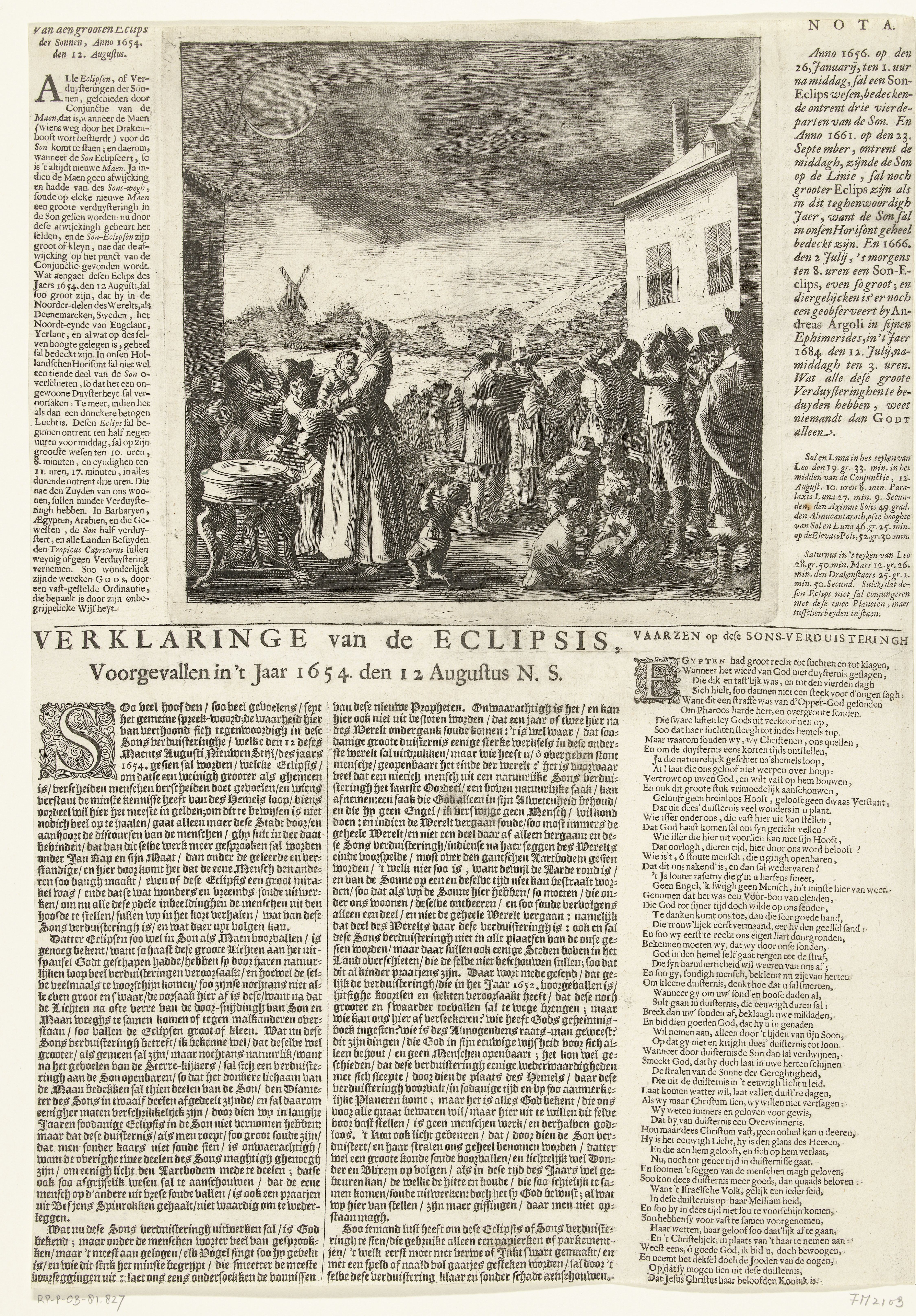
Dutch pamphlet published in Amsterdam on the solar eclipse of 12 August 1654 (Rijksprentenkabinet, Rijksmuseum Amsterdam,
RP-P-OB-81.827).
Kemp, A.G.H., “Vraag en Antwoord [de totale zonsverduistering van 17 Juni 1433]”, Hemel en Dampkring: Orgaan van de
Nederlandse Vereniging voor Weer- en Sterrenkunde en van de Vereniging voor Sterrenkunde, Meteorologie, Geophysica en Aanverwante
Wetenschappen in België, 52 (1954), 191 [ADS link].
van den Bergh, George, “Vraag en Antwoord [de totale zonsverduistering van 17 Juni 1433]”, Hemel en Dampkring: Orgaan
van de Nederlandse Vereniging voor Weer- en Sterrenkunde en van de Vereniging voor Sterrenkunde, Meteorologie, Geophysica en Aanverwante
Wetenschappen in België, 52 (1954), 191-192 [ADS link].
van den Bergh, George, “Nogmaals: De totale zonsverduistering van 17 Juni 1433 – ,,De laatste totale zonsverduistering in ons
land’’”, Hemel en Dampkring: Orgaan van de Nederlandse Vereniging voor Weer- en Sterrenkunde en van de Vereniging voor
Sterrenkunde, Meteorologie, Geophysica en Aanverwante Wetenschappen in België, 53 (1955), 92 [ADS
link].
Meeus, Jean, “Oppolzer’s foutieve voorspellingen van zonsverduisteringen”, Hemel en Dampkring: Orgaan van de Nederlandse
Vereniging voor Weer- en Sterrenkunde en van de Vereniging voor Sterrenkunde, Meteorologie, Geophysica en Aanverwante Wetenschappen in
België, 60 (1962), 133-137 [ADS link].
Meeus, Jean, “De totale zonsverduisteringen van 1433 en 1999”, Hemel en Dampkring: Orgaan van de Nederlandse Vereniging voor
Weer- en Sterrenkunde en van de Vereniging voor Sterrenkunde, Meteorologie, Geophysica en Aanverwante Wetenschappen in België,
61 (1963), 1-11 [ADS link].
Meeus, Jean, “Les prochaines éclipses totales ou annulaires de Soleil en Belgique ou dans son voisinage immédiat”,
Ciel et Terre: Bulletin de la Société Belge d’Astronomie, de Météorologie et de Physique du Globe, 80
(1964), 17-37 [ADS link].
Carton, Wilhelm H.C., “De laatste totale zonsverduistering in Nederland”, Zenit: Populair wetenschappelijk tijdschrift over sterrenkunde,
weerkunde, ruimtevaart en ruimte-onderzoek, 11 (1984), 422-423 [ADS link].
Lindemann, Anton J., “De totale zonsverduistering van 17 juni 1433”, Zenit: Populair wetenschappelijk tijdschrift over
sterrenkunde, weerkunde, ruimtevaart en ruimte-onderzoek, 23 (1996), 339 [ADS link].
Nieuwenhuis, Henk, “De raadselachtige zonsverduistering van 3 mei 1715”, Zenit: Populair wetenschappelijk tijdschrift over
sterrenkunde, weerkunde, ruimtevaart en ruimte-onderzoek, 26 (1999), 324-325 [ADS link].
Calvisius, Sethus, Opus chronologicum: Ex autoritate potissiumum sacrae scripturae et historicorum fide dignissimorum ad motum luminarium
coelestium, tempora et annos distinguentium. Editio altera & auctior & correctior (Frankfurt an der Oder: Impensis Johannis Thymii
Bibliopolae, 1620) [e-rara link].
Riccioli, Giovanni Baptista, Almagestum Novum: Astronomiam veterem novamque complectens observatiobus aliorum et propriis novisque
theorematibus, problematibus ac tabulis promotam in tres tomos distributam (Bologna: Haeredis Victorii Benatii, 1651/1665), 3 vols.
[e-rara link].
de la Hire, Philippe, Tabularum Astronomicarum, Pars Prior: De Motibus Solis et Lunæ, nec-non de Positione Fixarum ex ipsis
Observationibus deductis; cum usu Tabularum, cui adjecta est. Geometrica Methodus computandarum Eclipsium per solam triangulorum analysim ad
Meridianum Parisiensem (Paris: Stephan Michallet, 1687) [Google
Books link].
Halley, Edmund, “Emendationes & Notæ in tria loca vitiose edita in Textu vulgato Naturalis Historiæ C. Plinii”,
Philosophical Transactions, Giving some Account of the Present Undertakings, Studies and Labours of the Ingenious, in many Considerable Parts
of the World, 17 (1691), 535-540 [JSTOR link].
de la Hire, Philippe, Tabulæ Astronomicæ Ludovici Magni Jussu et Munificentia exaratæ et in lucem editæ, in quibus Solis,
Lunæ reliquorumque Planetarum motus ex ipsis observationibus, nullâ adhibitâ hypothesi, traduntur; habenturque præcipuarum
Fixarum in nostro Horizonte conspicuarum positiones, ineundi Calculi Methodus, cum Geometricè ratione computandarum Eclipsium solè
triangulorum rectilineorum Analysi, breviter exponitur. Adjecta sunt Descriptio, Constructio & Usus Instrumentorum Astronomiæ novæ
practicæ inservientium, variaque Problemata Astronomis Geographique perutilia (Paris: Jean Boudot, 1702)
[e-rara link].
Mackay, Andrew, The Theory and Practice of Finding the Longitude at Sea or Land: to which are Added, Various Methods of Determining the Latitude
of a Place, and Variation of the Compass, with New Tables (London: Andrew Mackay, 1809), 3rd ed., 2 vols.
[Internet Archive link / Internet rchive link].
Zech, Julius, Astronomische Untersuchungen über die Mondfinsternisse des Almagest (Leipzig: Weidmann’sche Buchhandliung, 1851)
[BSB link].
Zech, Julius, Astronomische Untersuchungen über die wichtigeren Finsternisse, welche von den Schriftstellern des classischen Alterthums
erwähnt werden (Leipzig: S. Hirzel, 1853) [BSB
link].
Oppert, Jules, “Restoration of the Berosus Canon”, in: R.K. Douglas (ed.), Transactions of the Second Session of the
International Congress of Orientalists, Held in London in September, 1874 (London: Trübner & Co., 1876), pp. 46-50
[Internet Archive link].
Ginzel, Friedrich Karl, “Astronomische Untersuchungen über Finsternisse: I. Abhandlung. Über die zwischen 26 und 103 n. Chr.
stattgefundenen Sonnenfinsternisse im Allgemeinen und die Finsterniss des Plutarch insbesonders”, Sitzungsberichte der Kaiserlichen Akademie
der Wissenschaften zu Wien, Mathematisch-Naturwissenschaftliche Classe, 85 (1882), II. Abtheilung, 663-747
[Google Books link].
Ginzel, Friedrich Karl, “Astronomische Untersuchungen über Finsternisse: II. Abhandlung. Grundlagen aus historischen
Sonnenfinsternissen zur Ableitung empirischer Correctionen der Mondbahn”, Sitzungsberichte der Kaiserlichen Akademie der Wissenschaften zu
Wien, Mathematisch-Naturwissenschaftliche Classe, 88 (1883), II. Abtheilung, 629-755
[Google Books link].
Ginzel, Friedrich Karl, “Astronomische Untersuchungen über Finsternisse: III. Abhandlung. Ermittlung empirischer Correctionen der Bahn
des Mondes”, Sitzungsberichte der Kaiserlichen Akademie der Wissenschaften zu Wien, Mathematisch-Naturwissenschaftliche Classe,
89 (1884), II. Abtheilung, 491-559 [Google Books link].
von Haerdtl, Eduard, “Astronomische Beiträge zur assyrischen Chronologie”, Denkschriften der Kaiserlichen Akademie der Wissenschaften
zu Wien, Mathematisch-Naturwissenschaftliche Classe, 49 (1885), II. Abtheilung, 153-196
[Internet Archive link].
Mahler, Eduard, “Die centralen Sonnenfinsternisse des XX. Jahrhunderts”, Denkschriften der Kaiserlichen Akademie der Wissenschaften
zu Wien, Mathematisch-Naturwissenschaftliche Classe, 49 (1885), II. Abtheilung, 239-276
[Internet Archive link].
Mahler, Eduard, “Astronomische Untersuchung über die in der Bibel erwähnte ägyptische Finsterniss”, Sitzungsberichte der
Kaiserlichen Akademie der Wissenschaften zu Wien, Mathematisch-Naturwissenschaftliche Classe, 91 (1885), II. Abtheilung, 987-1001
[Zobodat link].
Ginzel, Friedrich Karl, “Über einige historische, besonders in altspanischen Geschichtsquellen erwähnte Sonnenfinsternisse”,
Sitzungsberichte der königlich preussischen Akademie der Wissenschaften zu Berlin – Jahrgang 1886 (Berlin: Königlichen
Akademie der Wissenschaften, 1886), 963-981 + Tafeln XIV-XV [Internet Archive
link].
Mahler, Eduard, “Astronomische Untersuchungen über in hebräischen Schriften erwähnte Finsternisse: I. Theil. Die biblischen
Finsternisse”, Sitzungsberichte der Kaiserlichen Akademie der Wissenschaften zu Wien, Mathematisch-Naturwissenschaftliche Classe, 92
(1886), II. Abtheilung, 939-966 [Google Books link] – lists
solar eclipses visible from Palestina from –1790 to –1750, –1608 to –1570, –1334 to –1329, –1300 to –1280 and
–1113 to –1063.
Mahler, Eduard, “Astronomische Untersuchungen über in hebräischen Schriften erwähnte Finsternisse: II. Theil. Die prophetischen
Finsternisse”, Sitzungsberichte der Kaiserlichen Akademie der Wissenschaften zu Wien, Mathematisch-Naturwissenschaftliche Classe, 92
(1886), II. Abtheilung, 1102-1121 [Google Books link] – lists
solar eclipses visible from Jerusalem between –800 and –550.
Mahler, Eduard, “Untersuchung einer im Buche „Nahum” auf den Untergang Nineve’s bezogenen Finsterniss”, Sitzungsberichte
der Kaiserlichen Akademie der Wissenschaften zu Wien, Mathematisch-Naturwissenschaftliche Classe, 93 (1886), II. Abtheilung, 455-469
[Google Books link].
Ginzel, Friedrich Karl, “Über einige von persischen und arabischen Schriftstellern erwähnte Sonnen- und Mondfinsternisse”,
Sitzungsberichte der königlich preussischen Akademie der Wissenschaften zu Berlin – Jahrgang 1887 (Berlin: Königlichen
Akademie der Wissenschaften, 1887), 709-714 [Internet Archive
link].
Ginzel, Friedrich Karl, “Ueber die geringste Phase, welche bei der Beobachtung von Sonnenfinsternissen mit freiem Auge noch gesehen werden
kann”, Astronomische Nachrichten, 118 (1887), 119-122 [ADS link].
Mahler, Eduard, “Über eine in einer syrischen Grabinschrift erwähnte Sonnenfinsterniss”, Sitzungsberichte der
Kaiserlichen Akademie der Wissenschaften zu Wien, Mathematisch-Naturwissenschaftliche Classe, 95 (1888), II. Abtheilung,
359-366 [Google Books link].
Schiaparelli, Giovanni Virginio, “I primordi dell’astronomia presso i babilonesi”, Scientia: Rivista di Scienza, 3 (1908?),
36-?? [not seen].
Boll, Franz, “Finsternisse (Sonnen- und Mondfinsternisse)”, in: G. Wissowa (ed.), Paulys Real-Encyclopädie der classischen
Altertumswissenschaft: Neue Bearbeitung (Stuttgart: J.B. Metzlersche Buchhandlung, 1909), Band VI.2, Halbband 12, cols. 2329-2364
[Internet Archive link].
Fotheringham, John Knight, Historical Eclipses, being the Halley Lecture delivered 17 May 1921 (Oxford: Clarendon Press, 1921)
[Internet Archive link].
Willson, Robert Wheeler, Astronomical Notes on the Maya Codices (Cambridge [MA]: Peabody Museum of American Archaeology and Ethnology,
1924 [= Papers of the Peabody Museum of American Archaeology and Ethnology (Harvard University), 6, nr. 3])
[Harvard Library link].
Hoang, Pierre, Catalogue des éclipses de soleil et de lune relatées dans les documents chinois et collationnées avec le canon
de Th. Ritter v. Oppolzer (Shanghai: Imprimerie de la Mission Catholique, 1925 [= Variétés Sinilogiques, nr. 56])
[Gallica link].
Crommelin, Andrew Claude de la Cherois, “The Eclipse Charts in Oppolzer’s Canon”, The Observatory: A Monthly Review of
Astronomy, 53 (1930), 310 [ADS link].
Strömgren, Svante Elis & Strömgren, Bengt Georg Daniel, Lehrbuch der Astronomie (Berlin: Julius Springer Verlag, 1933),
pp. 195-196.
Neugebauer, Otto E., “Untersuchungen zur antiken Astronomie III. Die babylonische Theorie der Breitenbewegung des Mondes”,
Quellen und Studien zur Geschichte der Mathematik, Astronomie und Physik, ser. B, 4 (1937), 193-346.
Dubs, Homer H., “Solar Eclipses during the Former Han Period”, Osiris: ???, 5 (1938), 499-522
[JSTOR link].
Needham, Joseph, Science and Civilisation in China: Vol. 3. Mathematics and the Sciences of the Heavens and the Earth (Cambridge:
Cambridge University Press, 1959), pp. 409-423.
Newton, Robert R., Medieval Chronicles and the Rotation of the Earth (Baltimore/London: Johns Hopkins University Press, 1972)
[Internet Archive link].
Neugebauer, Otto E., A History of Ancient Mathematical Astronomy (Berlin/Heidelberg/New York: Springer Verlag, 1975), 3 vols.
Smiley, Charles Hugh, “The Solar Eclipse Warning Table in the Dresden Codex”, in: A.F. Aveni (ed.), Archaeoastronomy in Pre-Columbian
America (Austin: University of Texas Press, 1975), pp. 247-256 [ADS link].
Cohen, Alvin P. & Newton, Robert R., “Solar Eclipses Recorded in China During the Tarng Dynasty”, Monumenta Serica: Journal of
Oriental Studies, 35 (1981/83), 347-430 [JSTOR link].
Zirker, Jack B., Total Eclipses of the Sun (New York: Van Nostrand
Reinhold Company, 1981) – reprinted with additions in 1991 by Princeton University Press (Princeton).
Bricker, Harvey M. & Bricker, Victoria R., “Classic Maya Prediction of Solar Eclipses”, Current Anthropology, 24
(1983), 1-23 [JSTOR link].
Closs, M.P., “Cognitive Aspects of Ancient Maya Eclipse Theory”, in: A.F. Aveni (ed.), World Archaeoastronomy: Selected
Papers from the 2nd Oxford International Conference on Archaeoastronomy held at Merida, Yucatan, Mexico, 13-17 January, 1986
(Cambridge: Cambridge University Press, 1989), pp. 389-415.
Débarbat, Suzanne, “Historical Eclipses in Europe”, Contributions of the Astronomical Observatory Skalnaté Pleso,
28 (1999), 163-172 [ADS link].