Future_Ems:
Impact of climate change and human intervention on hydrodynamics
and environmental conditions in the Ems-Dollart estuary:
an integrated data-modelling approach
NWO-BMBF project
839.11.004
Prof. dr. H.E. de Swart - Dr.
T. Badewien - Dr. H.M. Schuttelaars - Prof. dr. E. Stanev
Research
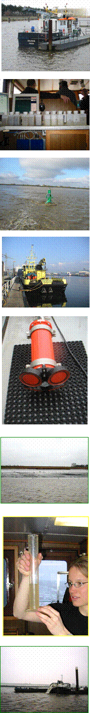
Measurements
The present project builds upon earlier projects that focused on the Ems. One of them was the LOICZ-funded project 'Dynamics of turbidity in estuaries: coupling of morphology and biology' (2005-2008). In this period we have made much progress in
researching the turbidity maximum of the Ems Estuary. We have planned
and executed numerous field campaigns over the year to measure various
biological and physical parameters. Field Campaigns occurred in each
month from February to October 2005, and required coordinating the efforts
of various Dutch and German agencies and companies, including WSA Emden,
Niedersachsen Ports GmBH, Rijkswaterstaat, NIOZ,
Bundesanstalt fuer Gewasserkunde (BfG), Bundesanstalt fur Wasserbau
(BAW-Hamburg), and Aquavision.
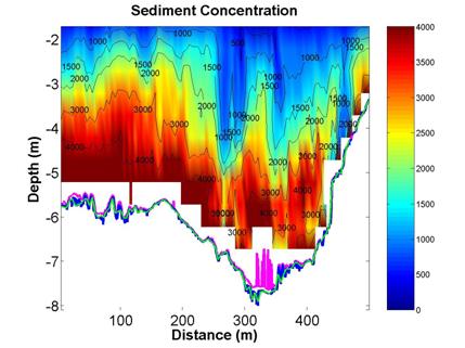
Figure 1: Sediment Concentration at
a cross-section of the Ems River near Pogum in March, 2005 during the flood
tide. Blank areas refer to sediment concentrations greater than 5 g/L.
Note that fluid mud is beginning to pool in the bottom of the main channel,
as evidenced by the deviation of the 210 kHz echosounder (magenta line) from
the 15 kHz echosounder (blue line).
Using the ships of NP, RWS, and WSA Emden, we measured
both along the main axis of the river and estuary and along selected
cross-sections. Measurements include physical variables such as
velocity (ADCP), sediment concentration (ADCP and OBS), salinity, and
temperature and biological measurements such as fluorescence (for algae
concentrations), nutrients (e.g. phosphorous, silicates, and nitrogen), and
oxygen concentration. Experiments have resumed in February 2006.
back to top
Analysis
Our
analysis of field data shows that sediment concentrations at the turbidity
maximum are large enough to significantly affect the density, mixing and
flow patterns of water in the vertical and longitudinal directions.
Moreover, the distribution of sediment concentration along the main axis of
the estuary is not symmetrical around the turbidity maximum (see figure 2).
The tidally-averaged circulation patterns set up by the tides, the
freshwater-saltwater density differences, and the longitudinal gradients in
turbidity also affect the distribution of biological parameters such as
algae and oxygen concentration (figure 2). Our results have led us to
begin designing an analytical model that can look
specifically at the formation of turbidity currents at the estuarine
turbidity maximum and its affect on the gravitational circulation of the
estuary.
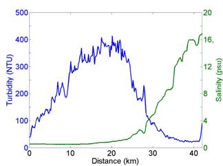 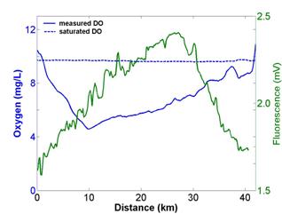
Figure 2:
Distribution of Turbidity, Salinity, oxygen, and Fluorescence in surface
water along a longitudinal transect of the Ems River on September 28, 2005.
Note the asymmetric profile of turbidity and the low oxygen concentrations.
In 2006 we plan to continue our experiments, using the
knowledge we have learned in the last year to refine our techniques. During
this year we will focus more on fixed measurements and cross-sectional
measurements to gain better knowledge of how sediment concentrations vary
over a tide and what physical forces play a role. Moreover, we will
specifically try to measure the currents that are being formed by the
turbidity, and look at how biological parameters are mixed through the water
column and over the length of the river.
back to top
Modeling
We are currently developing
analytical models to explain the asymmetric distribution of sediment
concentration around the turbidity maximum of the Ems Estuary (see figure 2).
These models help us to understand the circulation patterns
caused by longitudinal gradients in salinity and sediment concentration and how they are affected by river flow and
tides. In addition, we are also applying a 2D, semi-analytical model of the Ems to investigate the effect of deepening
from 5m to 7m on the residual circulation and the location of the turbidity
maximum. Finally, we are also investigating the mixing of sediment and
biological parameters through the water column using a state-of-the-art
turbulence modelling program (General Ocean Turbulence Model, GOTM).
We will continue our analysis of the data we collect and get better
estimates of sediment concentration, velocity, turbulence in the water, and
biological parameters. We will also investigate seasonal influences on
both the physical and biological measurements.
back to top
More Information/Downloads
See list of publications.
back to top
The estuarine group is part of the
Coastal and Shelf Sea Dynamics group of the Institute for Marine and Atmospheric Studies, Utrecht (IMAU).
The IMAU is part of the Department of Physics and
Astronomy at the University of Utrecht, Netherlands.
This project is financed by the Bundesministerium fur Bildung und Forschung (BMBF) and by the Netherlands Organization
for Scientific Research (NWO, see http://www.nwo.nl/), as part of the international Wadden Sea programme (GEORISK project).
| Contact Info: |
|
|
|---|
|
Institute for Marine and
Atmospheric Studies, Utrecht
Utrecht University
PO Box 80005
3508 TA Utrecht
The Netherlands
|
Huib de Swart
Phone: (+31/0) 030 253 3275
Fax: (+31/0) 030 254 3163
E-mail:
h.e.deswart@ uu.nl
|
|
last modified:
January 2, 2013 |